


Bois de l'eouviere. Saint Cassien

Michel DUBOIS
User
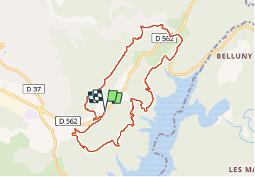

Length
10.3 km

Max alt
368 m

Uphill gradient
303 m
Km-Effort
14.3 km

Min alt
162 m

Downhill gradient
303 m
Boucle
Yes
Creation date :
2020-01-09 07:34:23.776
Updated on :
2020-01-09 10:27:06.313
2h51
Difficulty : Very easy

FREE GPS app for hiking
 SityTrail
IGN / Geographical institutes
SityTrail Plus
The world is yours!
About
Trail Walking of 10.3 km to be discovered at Provence-Alpes-Côte d'Azur, Var, Montauroux. This trail is proposed by Michel DUBOIS.
Photos


Positioning
Country:
France
Region :
Provence-Alpes-Côte d'Azur
Department/Province :
Var
Municipality :
Montauroux
Location:
Unknown
Start:(Dec)
Start:(UTM)
322578 ; 4829658 (32T) N.
Comments