


randonnée urbaine Rennes

nolsim
User

Length
13.6 km

Max alt
57 m

Uphill gradient
110 m
Km-Effort
15.1 km

Min alt
27 m

Downhill gradient
109 m
Boucle
Yes
Creation date :
2020-01-09 12:46:26.737
Updated on :
2020-01-09 15:54:45.872
3h07
Difficulty : Easy

FREE GPS app for hiking
 SityTrail
IGN / Geographical institutes
SityTrail Plus
The world is yours!
About
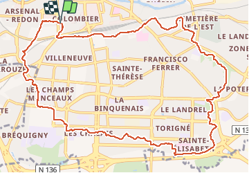
Trail Walking of 13.6 km to be discovered at Brittany, Ille-et-Vilaine, Rennes. This trail is proposed by nolsim.
Description
itinéraire dans la ville de Rennes
Positioning
Country:
France
Region :
Brittany
Department/Province :
Ille-et-Vilaine
Municipality :
Rennes
Location:
Quartiers Centre
Start:(Dec)
Start:(UTM)
597994 ; 5328701 (30U) N.
Comments