


ERNONHEID PROJET JS

fputters
User
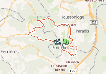

Length
14.3 km

Max alt
414 m

Uphill gradient
407 m
Km-Effort
19.8 km

Min alt
236 m

Downhill gradient
404 m
Boucle
Yes
Creation date :
2020-01-09 16:15:29.668
Updated on :
2020-01-09 16:16:48.66
4h11
Difficulty : Difficult

FREE GPS app for hiking
 SityTrail
IGN / Geographical institutes
SityTrail Plus
The world is yours!
About
Trail Walking of 14.3 km to be discovered at Wallonia, Liège, Aywaille. This trail is proposed by fputters.
Description
trajet raccourci de balade du site (20 km)
Positioning
Country:
Belgium
Region :
Wallonia
Department/Province :
Liège
Municipality :
Aywaille
Location:
Ernonheid
Start:(Dec)
Start:(UTM)
689474 ; 5586757 (31U) N.
Comments