


Laives Montceau ragny page 106

grasgilbert
User
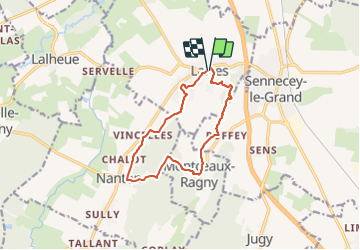

Length
11.4 km

Max alt
337 m

Uphill gradient
294 m
Km-Effort
15.3 km

Min alt
193 m

Downhill gradient
295 m
Boucle
Yes
Creation date :
2020-01-09 12:29:17.252
Updated on :
2024-12-27 16:56:05.095
3h28
Difficulty : Difficult

FREE GPS app for hiking
 SityTrail
IGN / Geographical institutes
SityTrail Plus
The world is yours!
About
Trail Walking of 11.4 km to be discovered at Bourgogne-Franche-Comté, Saône-et-Loire, Laives. This trail is proposed by grasgilbert.
Description
Montceau ragny
Positioning
Country:
France
Region :
Bourgogne-Franche-Comté
Department/Province :
Saône-et-Loire
Municipality :
Laives
Location:
Unknown
Start:(Dec)
Start:(UTM)
641313 ; 5167411 (31T) N.
Comments
très bien