


Sart Bernard

r.genette
User
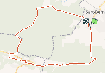

Length
11.2 km

Max alt
280 m

Uphill gradient
259 m
Km-Effort
14.6 km

Min alt
127 m

Downhill gradient
258 m
Boucle
Yes
Creation date :
2020-01-10 08:23:55.157
Updated on :
2020-01-10 15:01:12.006
2h36
Difficulty : Medium

FREE GPS app for hiking
 SityTrail
IGN / Geographical institutes
SityTrail Plus
The world is yours!
About
Trail Walking of 11.2 km to be discovered at Wallonia, Namur, Assesse. This trail is proposed by r.genette.
Description
Rando intéressante. Un dénivelé à mi chemin..
Positioning
Country:
Belgium
Region :
Wallonia
Department/Province :
Namur
Municipality :
Assesse
Location:
Sart-Bernard
Start:(Dec)
Start:(UTM)
638295 ; 5584818 (31U) N.
Comments