


bedat chanturge

jean-charlesSIMAND
User
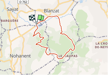

Length
7.7 km

Max alt
604 m

Uphill gradient
240 m
Km-Effort
10.9 km

Min alt
374 m

Downhill gradient
242 m
Boucle
Yes
Creation date :
2020-01-12 09:37:31.77
Updated on :
2020-01-12 10:39:23.732
1h01
Difficulty : Very easy

FREE GPS app for hiking
 SityTrail
IGN / Geographical institutes
SityTrail Plus
The world is yours!
About
Trail Running of 7.7 km to be discovered at Auvergne-Rhône-Alpes, Puy-de-Dôme, Sayat. This trail is proposed by jean-charlesSIMAND.
Positioning
Country:
France
Region :
Auvergne-Rhône-Alpes
Department/Province :
Puy-de-Dôme
Municipality :
Sayat
Location:
Unknown
Start:(Dec)
Start:(UTM)
505049 ; 5074184 (31T) N.
Comments