


Servian

PiloudeBamako
User
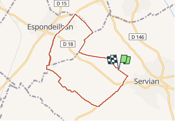

Length
10.5 km

Max alt
98 m

Uphill gradient
108 m
Km-Effort
12 km

Min alt
51 m

Downhill gradient
108 m
Boucle
Yes
Creation date :
2020-01-12 11:52:32.0
Updated on :
2020-01-25 21:24:20.693
1h08
Difficulty : Difficult

FREE GPS app for hiking
 SityTrail
IGN / Geographical institutes
SityTrail Plus
The world is yours!
About
Trail Running of 10.5 km to be discovered at Occitania, Hérault, Servian. This trail is proposed by PiloudeBamako.
Description
Course à pied
Positioning
Country:
France
Region :
Occitania
Department/Province :
Hérault
Municipality :
Servian
Location:
Unknown
Start:(Dec)
Start:(UTM)
523357 ; 4808599 (31T) N.
Comments