


GR NEAUPHLE ST NOM

NUITEVEN
User
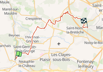

Length
25 km

Max alt
192 m

Uphill gradient
444 m
Km-Effort
31 km

Min alt
65 m

Downhill gradient
388 m
Boucle
No
Creation date :
2017-12-03 00:00:00.0
Updated on :
2017-12-03 00:00:00.0
6h33
Difficulty : Easy

FREE GPS app for hiking
 SityTrail
IGN / Geographical institutes
SityTrail Plus
The world is yours!
About
Trail Walking of 25 km to be discovered at Ile-de-France, Yvelines, Villiers-Saint-Frédéric. This trail is proposed by NUITEVEN.
Positioning
Country:
France
Region :
Ile-de-France
Department/Province :
Yvelines
Municipality :
Villiers-Saint-Frédéric
Location:
Unknown
Start:(Dec)
Start:(UTM)
417507 ; 5407649 (31U) N.
Comments