circuit sans soucis

olivier26
User
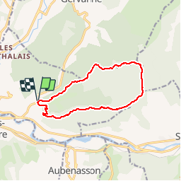

Length
12.2 km

Max alt
671 m

Uphill gradient
485 m
Km-Effort
18.7 km

Min alt
257 m

Downhill gradient
490 m
Boucle
Yes
Creation date :
2014-12-10 00:00:00.0
Updated on :
2014-12-10 00:00:00.0
3h39
Difficulty : Easy

FREE GPS app for hiking
 SityTrail
IGN / Geographical institutes
SityTrail Plus
The world is yours!
About
Trail Walking of 12.2 km to be discovered at Auvergne-Rhône-Alpes, Drôme, Mirabel-et-Blacons. This trail is proposed by olivier26.
Description
belle randonnée facile a faire en famille
Positioning
Country:
France
Region :
Auvergne-Rhône-Alpes
Department/Province :
Drôme
Municipality :
Mirabel-et-Blacons
Location:
Unknown
Start:(Dec)
Start:(UTM)
668153 ; 4952961 (31T) N.
Comments