


Ton circuit de marche active

DaVinci
User
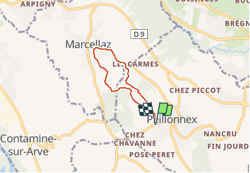

Length
4.6 km

Max alt
722 m

Uphill gradient
83 m
Km-Effort
5.7 km

Min alt
654 m

Downhill gradient
82 m
Boucle
Yes
Creation date :
2020-01-14 17:33:24.207
Updated on :
2020-01-14 17:34:36.62
46m
Difficulty : Easy

FREE GPS app for hiking
 SityTrail
IGN / Geographical institutes
SityTrail Plus
The world is yours!
About
Trail Nordic walking of 4.6 km to be discovered at Auvergne-Rhône-Alpes, Upper Savoy, Peillonnex. This trail is proposed by DaVinci.
Positioning
Country:
France
Region :
Auvergne-Rhône-Alpes
Department/Province :
Upper Savoy
Municipality :
Peillonnex
Location:
Unknown
Start:(Dec)
Start:(UTM)
296927 ; 5111961 (32T) N.
Comments