


SityTrail - JG Apremont 10 URCC

Francine
User
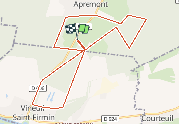

Length
11 km

Max alt
82 m

Uphill gradient
84 m
Km-Effort
12.1 km

Min alt
58 m

Downhill gradient
84 m
Boucle
Yes
Creation date :
2020-01-15 14:00:19.428
Updated on :
2020-01-15 14:01:26.08
2h00
Difficulty : Very easy

FREE GPS app for hiking
 SityTrail
IGN / Geographical institutes
SityTrail Plus
The world is yours!
About
Trail Nordic walking of 11 km to be discovered at Hauts-de-France, Oise, Apremont. This trail is proposed by Francine.
Description
sortie du 16 01 2020
Positioning
Country:
France
Region :
Hauts-de-France
Department/Province :
Oise
Municipality :
Apremont
Location:
Unknown
Start:(Dec)
Start:(UTM)
464071 ; 5451649 (31U) N.
Comments