


Amicale_TeteDor

d.rognon
User
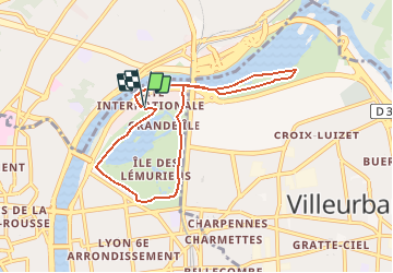

Length
7.4 km

Max alt
181 m

Uphill gradient
62 m
Km-Effort
8.2 km

Min alt
165 m

Downhill gradient
58 m
Boucle
Yes
Creation date :
2020-01-15 17:04:34.595
Updated on :
2020-02-16 19:35:33.911
1h49
Difficulty : Medium

FREE GPS app for hiking
 SityTrail
IGN / Geographical institutes
SityTrail Plus
The world is yours!
About
Trail Walking of 7.4 km to be discovered at Auvergne-Rhône-Alpes, Métropole de Lyon, Lyon. This trail is proposed by d.rognon.
Description
Randonnée sans dénivelé (Parc de la Tête d'or, promenade le long des berges
Positioning
Country:
France
Region :
Auvergne-Rhône-Alpes
Department/Province :
Métropole de Lyon
Municipality :
Lyon
Location:
Lyon 6e Arrondissement
Start:(Dec)
Start:(UTM)
644026 ; 5071709 (31T) N.
Comments