


Vaugelas

raygautier
User
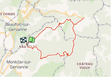

Length
19.4 km

Max alt
884 m

Uphill gradient
824 m
Km-Effort
30 km

Min alt
345 m

Downhill gradient
833 m
Boucle
Yes
Creation date :
2020-01-16 07:28:00.0
Updated on :
2020-01-17 07:52:08.716
7h10
Difficulty : Unknown

FREE GPS app for hiking
 SityTrail
IGN / Geographical institutes
SityTrail Plus
The world is yours!
About
Trail Walking of 19.4 km to be discovered at Auvergne-Rhône-Alpes, Drôme, Montclar-sur-Gervanne. This trail is proposed by raygautier.
Positioning
Country:
France
Region :
Auvergne-Rhône-Alpes
Department/Province :
Drôme
Municipality :
Montclar-sur-Gervanne
Location:
Unknown
Start:(Dec)
Start:(UTM)
670422 ; 4958697 (31T) N.
Comments