


boucle de Sieurac

tabouelle
User
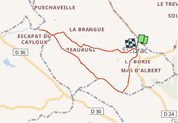

Length
7.5 km

Max alt
261 m

Uphill gradient
101 m
Km-Effort
8.8 km

Min alt
194 m

Downhill gradient
98 m
Boucle
Yes
Creation date :
2020-01-09 09:56:33.345
Updated on :
2020-01-17 14:07:02.741
3h29
Difficulty : Very easy

FREE GPS app for hiking
 SityTrail
IGN / Geographical institutes
SityTrail Plus
The world is yours!
About
Trail Walking of 7.5 km to be discovered at Occitania, Tarn, Sieurac. This trail is proposed by tabouelle.
Photos


Positioning
Country:
France
Region :
Occitania
Department/Province :
Tarn
Municipality :
Sieurac
Location:
Unknown
Start:(Dec)
Start:(UTM)
427829 ; 4850608 (31T) N.
Comments