


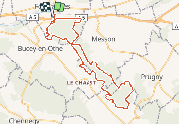
FONTVANNES 19 01 2020

Tollard
User

Length
21 km

Max alt
261 m

Uphill gradient
376 m
Km-Effort
26 km

Min alt
148 m

Downhill gradient
376 m
Boucle
Yes
Creation date :
2020-01-19 08:15:55.162
Updated on :
2020-01-21 08:29:43.624
2h17
Difficulty : Easy

FREE GPS app for hiking
 SityTrail
IGN / Geographical institutes
SityTrail Plus
The world is yours!
About
Trail Mountain bike of 21 km to be discovered at Grand Est, Aube, Fontvannes. This trail is proposed by Tollard.
Positioning
Country:
France
Region :
Grand Est
Department/Province :
Aube
Municipality :
Fontvannes
Location:
Unknown
Start:(Dec)
Start:(UTM)
564731 ; 5347024 (31U) N.
Comments