


Rando Meures Sexf.Calvez

janussity
User
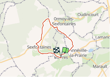

Length
11 km

Max alt
403 m

Uphill gradient
186 m
Km-Effort
13.4 km

Min alt
268 m

Downhill gradient
187 m
Boucle
Yes
Creation date :
2020-01-16 13:11:30.772
Updated on :
2020-01-21 06:13:24.443
3h01
Difficulty : Easy

FREE GPS app for hiking
 SityTrail
IGN / Geographical institutes
SityTrail Plus
The world is yours!
About
Trail Walking of 11 km to be discovered at Grand Est, Haute-Marne, Meures. This trail is proposed by janussity.
Description
depart derrière l'église.
Lavoir de Sexfontaine
Côte 403
Lisiere du bois
Vers Marie Calvez en longeant propriété privée.
A gauche vers cimetière.
Eglise.
Reconnaissance le 16/01/2020 par beau temps frais.
Positioning
Country:
France
Region :
Grand Est
Department/Province :
Haute-Marne
Municipality :
Meures
Location:
Unknown
Start:(Dec)
Start:(UTM)
653415 ; 5339855 (31U) N.
Comments