


Tanneron les mimosas

Michel DUBOIS
User
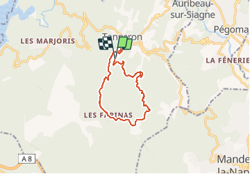

Length
12 km

Max alt
480 m

Uphill gradient
431 m
Km-Effort
17.8 km

Min alt
192 m

Downhill gradient
438 m
Boucle
Yes
Creation date :
2020-01-23 07:48:45.027
Updated on :
2020-01-23 11:32:59.9
3h25
Difficulty : Very easy

FREE GPS app for hiking
 SityTrail
IGN / Geographical institutes
SityTrail Plus
The world is yours!
About
Trail Walking of 12 km to be discovered at Provence-Alpes-Côte d'Azur, Var, Tanneron. This trail is proposed by Michel DUBOIS.
Photos


Positioning
Country:
France
Region :
Provence-Alpes-Côte d'Azur
Department/Province :
Var
Municipality :
Tanneron
Location:
Unknown
Start:(Dec)
Start:(UTM)
328240 ; 4827672 (32T) N.
Comments
En fait assez phisique