


jambes

sarriette
User
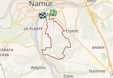

Length
11.1 km

Max alt
204 m

Uphill gradient
218 m
Km-Effort
14 km

Min alt
77 m

Downhill gradient
219 m
Boucle
No
Creation date :
2020-01-23 12:32:59.856
Updated on :
2020-01-23 15:11:46.753
2h38
Difficulty : Medium

FREE GPS app for hiking
 SityTrail
IGN / Geographical institutes
SityTrail Plus
The world is yours!
About
Trail Walking of 11.1 km to be discovered at Wallonia, Namur, Namur. This trail is proposed by sarriette.
Positioning
Country:
Belgium
Region :
Wallonia
Department/Province :
Namur
Municipality :
Namur
Location:
Jambes
Start:(Dec)
Start:(UTM)
633144 ; 5590879 (31U) N.
Comments