Trail On foot Saint-Alban-d'Hurtières - Le grand Chat - col de l'Arbaretan - Photo

Le grand Chat - col de l'Arbaretan

© OpenStreetMap contributors
Length
Length
9.4 km
Max alt
Max alt
1988 m
Uphill gradient
Uphill gradient
509 m
Km-Effort
Km-Effort  
16.1 km
Min alt
Min alt
1528 m
Downhill gradient
Downhill gradient
506 m
Boucle
Boucle
Yes
Creation date :
2020-01-23 17:30:42.245
Updated on :
2020-09-12 14:01:59.373

(0 Reviews)

On foot
On foot
4h00
Difficulty : Difficult

Scan this QR Code to open this trail in the SityTrail application

FREE GPS app for hiking

Logo SityTrail SityTrail

IGN / Geographical institutes

Download SityTrail from the App Store Download SityTrail from Google Play

Logo SityTrail SityTrail Plus

The world is yours!

Download SityTrail from the App Store Download SityTrail from Google Play Download SityTrail on Huawei AppGallery

About

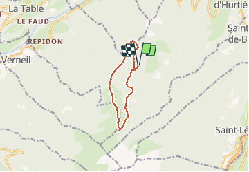
Trail On foot of 9.4 km to be discovered at Auvergne-Rhône-Alpes, Savoy, Saint-Alban-d'Hurtières. This trail is proposed by michel.pegaz.

Description

Départ parking de Teppe Verte prendre au nord la direction de Grand Leyat revenir vers le sud au col du Champet poursuivre dans la même  direction par les crêtes des Mollards puis le col de L'Albarétan. Vous passer par le lac des Grenouilles pour rejoindre le chalet de l'Albarétant.
Retour par le sentier à l'est des trois Mollards ou par le sentier de Barbeloup

Elevation profile

Positioning

Country:
France
Region :
Auvergne-Rhône-Alpes
Department/Province :
Savoy
Municipality :
Saint-Alban-d'Hurtières
Location:
Unknown
Start:(UTM)
283256 ; 5037718 (32T) N.


Close
My subscriptions