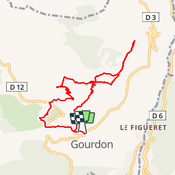
Trail Walking Gourdon - boucle de cavillore - Photo
 franquen
franquen

User

© OpenStreetMap contributors
Length
Length
9.4 km
Max alt
Max alt
1055 m
Uphill gradient
Uphill gradient
418 m
Km-Effort
Km-Effort  
15.1 km
Min alt
Min alt
738 m
Downhill gradient
Downhill gradient
432 m
Boucle
Boucle
Yes
Creation date :
2014-12-10 00:00:00.0
Updated on :
2014-12-10 00:00:00.0

(0 Reviews)

Walking
Walking
3h27
Difficulty : Medium

Scan this QR Code to open this trail in the SityTrail application

FREE GPS app for hiking

Logo SityTrail SityTrail

IGN / Geographical institutes

Download SityTrail from the App Store Download SityTrail from Google Play

Logo SityTrail SityTrail Plus

The world is yours!

Download SityTrail from the App Store Download SityTrail from Google Play Download SityTrail on Huawei AppGallery

About

Trail Walking of 9.4 km to be discovered at Provence-Alpes-Côte d'Azur, Maritime Alps, Gourdon. This trail is proposed by franquen.

Description

depart de Gourdon, montée au col de Cavillore (45mn), aller-retour à la "forteresse" (45 mn, une partie en encorbellement impressionante avec la vallée du loup en contrebas), reprise de la boucle sur la plateau puis descente vers la chapelle st Vincent et Gourdon (40mn).
rando sympa, paysages et vues superbes

Elevation profile

Points of interest

Point of interest Gourdon - Point 1 - Photo
franquen
GOURDON 

Positioning

Country:
France
Region :
Provence-Alpes-Côte d'Azur
Department/Province :
Maritime Alps
Municipality :
Gourdon
Location:
Unknown
Start:(UTM)
336919 ; 4842958 (32T) N.


Close
My subscriptions