


26 01 2020

jacquesduchesne
User

Length
8.5 km

Max alt
117 m

Uphill gradient
99 m
Km-Effort
9.8 km

Min alt
73 m

Downhill gradient
99 m
Boucle
Yes
Creation date :
2020-01-26 13:09:15.98
Updated on :
2020-01-26 14:57:22.493
1h47
Difficulty : Very easy

FREE GPS app for hiking
 SityTrail
IGN / Geographical institutes
SityTrail Plus
The world is yours!
About
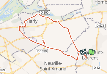
Trail Walking of 8.5 km to be discovered at Hauts-de-France, Aisne, Mesnil-Saint-Laurent. This trail is proposed by jacquesduchesne.
Positioning
Country:
France
Region :
Hauts-de-France
Department/Province :
Aisne
Municipality :
Mesnil-Saint-Laurent
Location:
Unknown
Start:(Dec)
Start:(UTM)
525458 ; 5519660 (31U) N.
Comments