


mirlondaine amay

michele23
User
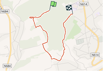

Length
3.3 km

Max alt
188 m

Uphill gradient
113 m
Km-Effort
4.7 km

Min alt
117 m

Downhill gradient
93 m
Boucle
No
Creation date :
2020-01-26 14:23:08.251
Updated on :
2020-01-26 15:26:57.863
1h03
Difficulty : Very easy

FREE GPS app for hiking
 SityTrail
IGN / Geographical institutes
SityTrail Plus
The world is yours!
About
Trail Walking of 3.3 km to be discovered at Wallonia, Liège, Amay. This trail is proposed by michele23.
Positioning
Country:
Belgium
Region :
Wallonia
Department/Province :
Liège
Municipality :
Amay
Location:
Amay
Start:(Dec)
Start:(UTM)
662610 ; 5602999 (31U) N.
Comments