


saint Sébastien d aigre feuille arsel

labarone
User
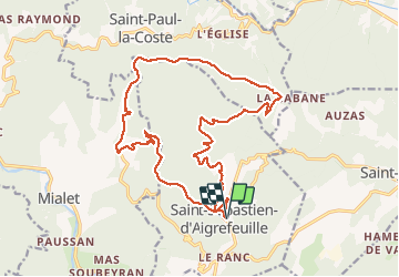

Length
21 km

Max alt
648 m

Uphill gradient
808 m
Km-Effort
32 km

Min alt
192 m

Downhill gradient
808 m
Boucle
Yes
Creation date :
2020-01-28 08:18:15.091
Updated on :
2020-01-29 21:34:35.114
5h45
Difficulty : Easy

FREE GPS app for hiking
 SityTrail
IGN / Geographical institutes
SityTrail Plus
The world is yours!
About
Trail Walking of 21 km to be discovered at Occitania, Gard, Saint-Sébastien-d'Aigrefeuille. This trail is proposed by labarone.
Description
Belle rando tranquille
Attention certaines revues telle que " les plus belles rando des cevennes" indiquent 17 kms5 alors qu elle fait 21 kms
Photos


Positioning
Country:
France
Region :
Occitania
Department/Province :
Gard
Municipality :
Saint-Sébastien-d'Aigrefeuille
Location:
Unknown
Start:(Dec)
Start:(UTM)
579607 ; 4884196 (31T) N.
Comments