


2020-01-29_23h49m32_Sur les traces de Manon
immortelles2020
prendre plaisir à faire plaisir
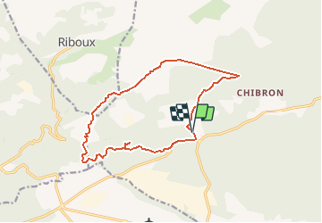

Length
12.9 km

Max alt
561 m

Uphill gradient
249 m
Km-Effort
16.3 km

Min alt
384 m

Downhill gradient
254 m
Boucle
Yes
Creation date :
2020-01-29 22:49:32.643
Updated on :
2025-02-11 06:45:47.122
3h41
Difficulty : Easy

FREE GPS app for hiking
 SityTrail
IGN / Geographical institutes
SityTrail Plus
The world is yours!
About
Trail Walking of 12.9 km to be discovered at Provence-Alpes-Côte d'Azur, Var, Signes. This trail is proposed by immortelles2020.
Description
facile
Positioning
Country:
France
Region :
Provence-Alpes-Côte d'Azur
Department/Province :
Var
Municipality :
Signes
Location:
Unknown
Start:(Dec)
Start:(UTM)
727288 ; 4795454 (31T) N.
Comments