


2020-01-30_11h14m54_J Vaux Ronquerolles

avdem
User
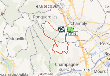

Length
10.1 km

Max alt
174 m

Uphill gradient
153 m
Km-Effort
12.2 km

Min alt
53 m

Downhill gradient
156 m
Boucle
Yes
Creation date :
2020-01-30 10:14:56.166
Updated on :
2020-01-30 10:15:01.489

FREE GPS app for hiking
 SityTrail
IGN / Geographical institutes
SityTrail Plus
The world is yours!
About
Trail of 10.1 km to be discovered at Hauts-de-France, Oise, Chambly. This trail is proposed by avdem.
Positioning
Country:
France
Region :
Hauts-de-France
Department/Province :
Oise
Municipality :
Chambly
Location:
Unknown
Start:(Dec)
Start:(UTM)
443870 ; 5445117 (31U) N.
Comments