


Culles les roches Le Château de l'Evêque page 56

grasgilbert
User
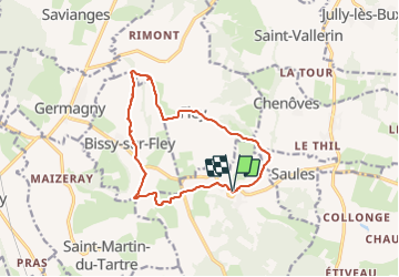

Length
12.8 km

Max alt
444 m

Uphill gradient
317 m
Km-Effort
17.1 km

Min alt
285 m

Downhill gradient
319 m
Boucle
Yes
Creation date :
2020-01-30 12:34:15.598
Updated on :
2022-02-04 10:09:30.954
3h40
Difficulty : Medium

FREE GPS app for hiking
 SityTrail
IGN / Geographical institutes
SityTrail Plus
The world is yours!
About
Trail Walking of 12.8 km to be discovered at Bourgogne-Franche-Comté, Saône-et-Loire, Culles-les-Roches. This trail is proposed by grasgilbert.
Positioning
Country:
France
Region :
Bourgogne-Franche-Comté
Department/Province :
Saône-et-Loire
Municipality :
Culles-les-Roches
Location:
Unknown
Start:(Dec)
Start:(UTM)
626477 ; 5167939 (31T) N.
Comments
bien