


sion

COMAN
User
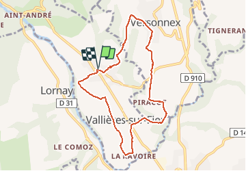

Length
8.3 km

Max alt
495 m

Uphill gradient
198 m
Km-Effort
11 km

Min alt
314 m

Downhill gradient
199 m
Boucle
Yes
Creation date :
2020-01-31 13:07:38.218
Updated on :
2020-01-31 17:07:12.073
2h32
Difficulty : Very easy

FREE GPS app for hiking
 SityTrail
IGN / Geographical institutes
SityTrail Plus
The world is yours!
About
Trail Walking of 8.3 km to be discovered at Auvergne-Rhône-Alpes, Upper Savoy, Vallières-sur-Fier. This trail is proposed by COMAN.
Positioning
Country:
France
Region :
Auvergne-Rhône-Alpes
Department/Province :
Upper Savoy
Municipality :
Vallières-sur-Fier
Location:
Val-de-Fier
Start:(Dec)
Start:(UTM)
725852 ; 5089333 (31T) N.
Comments