


bassin Cormoran

gdela
User
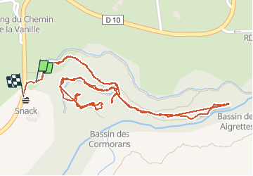

Length
2.6 km

Max alt
152 m

Uphill gradient
92 m
Km-Effort
3.9 km

Min alt
89 m

Downhill gradient
88 m
Boucle
Yes
Creation date :
2019-10-30 06:26:02.482
Updated on :
2020-01-31 17:12:18.161
1h22
Difficulty : Easy

FREE GPS app for hiking
 SityTrail
IGN / Geographical institutes
SityTrail Plus
The world is yours!
About
Trail Walking of 2.6 km to be discovered at Réunion, Unknown, Saint-Paul. This trail is proposed by gdela.
Positioning
Country:
France
Region :
Réunion
Department/Province :
Unknown
Municipality :
Saint-Paul
Location:
Unknown
Start:(Dec)
Start:(UTM)
317202 ; 7671912 (40K) S.
Comments