


Rando Pt Ste Maxence

domifon
User
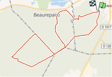

Length
12.3 km

Max alt
123 m

Uphill gradient
179 m
Km-Effort
14.7 km

Min alt
37 m

Downhill gradient
178 m
Boucle
Yes
Creation date :
2014-12-10 00:00:00.0
Updated on :
2014-12-10 00:00:00.0
2h21
Difficulty : Easy

FREE GPS app for hiking
 SityTrail
IGN / Geographical institutes
SityTrail Plus
The world is yours!
About
Trail Mountain bike of 12.3 km to be discovered at Hauts-de-France, Oise, Pont-Sainte-Maxence. This trail is proposed by domifon.


Positioning
Country:
France
Region :
Hauts-de-France
Department/Province :
Oise
Municipality :
Pont-Sainte-Maxence
Location:
Unknown
Start:(Dec)
Start:(UTM)
470778 ; 5460065 (31U) N.
Comments
