


Barry troglo et carrieres

jcboutin
User
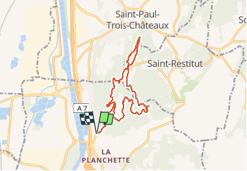

Length
16.9 km

Max alt
285 m

Uphill gradient
412 m
Km-Effort
22 km

Min alt
79 m

Downhill gradient
412 m
Boucle
Yes
Creation date :
2019-12-19 08:11:51.214
Updated on :
2020-02-02 09:01:56.298
5h42
Difficulty : Medium

FREE GPS app for hiking
 SityTrail
IGN / Geographical institutes
SityTrail Plus
The world is yours!
About
Trail Walking of 16.9 km to be discovered at Provence-Alpes-Côte d'Azur, Vaucluse, Bollène. This trail is proposed by jcboutin.
Positioning
Country:
France
Region :
Provence-Alpes-Côte d'Azur
Department/Province :
Vaucluse
Municipality :
Bollène
Location:
Unknown
Start:(Dec)
Start:(UTM)
639616 ; 4907416 (31T) N.
Comments