


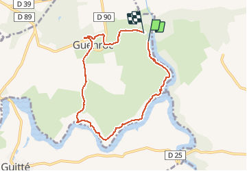
Guenroc

eric.deniau
User

Length
7.7 km

Max alt
101 m

Uphill gradient
116 m
Km-Effort
9.2 km

Min alt
53 m

Downhill gradient
109 m
Boucle
Yes
Creation date :
2020-02-02 08:51:12.0
Updated on :
2020-02-02 11:52:51.229
3h01
Difficulty : Unknown

FREE GPS app for hiking
 SityTrail
IGN / Geographical institutes
SityTrail Plus
The world is yours!
About
Trail Walking of 7.7 km to be discovered at Brittany, Côtes-d'Armor, Guenroc. This trail is proposed by eric.deniau.
Positioning
Country:
France
Region :
Brittany
Department/Province :
Côtes-d'Armor
Municipality :
Guenroc
Location:
Unknown
Start:(Dec)
Start:(UTM)
569520 ; 5352086 (30U) N.
Comments