


autour de Soultzeren

gdela
User
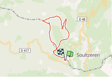

Length
7.1 km

Max alt
970 m

Uphill gradient
336 m
Km-Effort
11.6 km

Min alt
702 m

Downhill gradient
322 m
Boucle
Yes
Creation date :
2020-02-02 08:06:05.008
Updated on :
2020-02-02 16:04:14.619
2h53
Difficulty : Easy

FREE GPS app for hiking
 SityTrail
IGN / Geographical institutes
SityTrail Plus
The world is yours!
About
Trail Walking of 7.1 km to be discovered at Grand Est, Haut-Rhin, Stosswihr. This trail is proposed by gdela.
Positioning
Country:
France
Region :
Grand Est
Department/Province :
Haut-Rhin
Municipality :
Stosswihr
Location:
Unknown
Start:(Dec)
Start:(UTM)
357767 ; 5324823 (32U) N.
Comments
ras