


le rove de Daniel

Coryphene
User
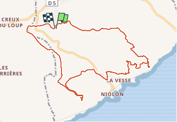

Length
13.6 km

Max alt
238 m

Uphill gradient
334 m
Km-Effort
18 km

Min alt
30 m

Downhill gradient
328 m
Boucle
Yes
Creation date :
2020-02-02 08:41:42.322
Updated on :
2020-02-02 17:51:12.133
6h14
Difficulty : Easy

FREE GPS app for hiking
 SityTrail
IGN / Geographical institutes
SityTrail Plus
The world is yours!
About
Trail Walking of 13.6 km to be discovered at Provence-Alpes-Côte d'Azur, Bouches-du-Rhône, Le Rove. This trail is proposed by Coryphene.
Positioning
Country:
France
Region :
Provence-Alpes-Côte d'Azur
Department/Province :
Bouches-du-Rhône
Municipality :
Le Rove
Location:
Unknown
Start:(Dec)
Start:(UTM)
681337 ; 4802785 (31T) N.
Comments