


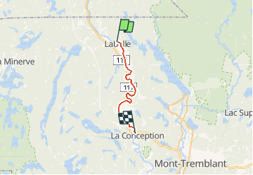
Rivière Rouge

DaVinci
User

Length
25 km

Max alt
212 m

Uphill gradient
133 m
Km-Effort
27 km

Min alt
194 m

Downhill gradient
143 m
Boucle
No
Creation date :
2020-02-03 18:15:57.134
Updated on :
2020-02-03 18:16:40.582
4h10
Difficulty : Medium

FREE GPS app for hiking
 SityTrail
IGN / Geographical institutes
SityTrail Plus
The world is yours!
About
Trail Canoe - kayak of 25 km to be discovered at Quebec, Les Laurentides, Labelle. This trail is proposed by DaVinci.
Positioning
Country:
Canada
Region :
Quebec
Department/Province :
Les Laurentides
Municipality :
Labelle
Location:
Unknown
Start:(Dec)
Start:(UTM)
520581 ; 5125299 (18T) N.
Comments