


Rivière Jacques Cartier

DaVinci
User
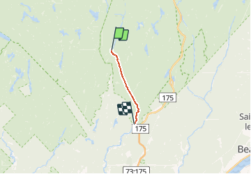

Length
25 km

Max alt
281 m

Uphill gradient
188 m
Km-Effort
28 km

Min alt
239 m

Downhill gradient
220 m
Boucle
No
Creation date :
2020-02-03 20:44:01.489
Updated on :
2020-02-03 20:44:39.061
4h15
Difficulty : Medium

FREE GPS app for hiking
 SityTrail
IGN / Geographical institutes
SityTrail Plus
The world is yours!
About
Trail Canoe - kayak of 25 km to be discovered at Quebec, La Jacques-Cartier, Lac-Croche. This trail is proposed by DaVinci.
Positioning
Country:
Canada
Region :
Quebec
Department/Province :
La Jacques-Cartier
Municipality :
Lac-Croche
Location:
Unknown
Start:(Dec)
Start:(UTM)
314189 ; 5242557 (19T) N.
Comments