


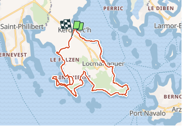
saint Pierre et locmariaquer

COGLAIS3
User

Length
20 km

Max alt
12 m

Uphill gradient
133 m
Km-Effort
22 km

Min alt
-1 m

Downhill gradient
130 m
Boucle
Yes
Creation date :
2020-02-04 08:26:09.1
Updated on :
2020-02-04 15:57:10.155
7h02
Difficulty : Very easy

FREE GPS app for hiking
 SityTrail
IGN / Geographical institutes
SityTrail Plus
The world is yours!
About
Trail Nordic walking of 20 km to be discovered at Brittany, Morbihan, Locmariaquer. This trail is proposed by COGLAIS3.
Positioning
Country:
France
Region :
Brittany
Department/Province :
Morbihan
Municipality :
Locmariaquer
Location:
Unknown
Start:(Dec)
Start:(UTM)
502568 ; 5269744 (30T) N.
Comments