


Lac Saint François

DaVinci
User
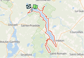

Length
81 km

Max alt
295 m

Uphill gradient
273 m
Km-Effort
85 km

Min alt
283 m

Downhill gradient
276 m
Boucle
Yes
Creation date :
2020-02-04 18:08:55.892
Updated on :
2020-02-04 18:10:59.352
13h30
Difficulty : Medium

FREE GPS app for hiking
 SityTrail
IGN / Geographical institutes
SityTrail Plus
The world is yours!
About
Trail Canoe - kayak of 81 km to be discovered at Quebec, Les Appalaches, Sainte-Praxède. This trail is proposed by DaVinci.
Positioning
Country:
Canada
Region :
Quebec
Department/Province :
Les Appalaches
Municipality :
Sainte-Praxède
Location:
Unknown
Start:(Dec)
Start:(UTM)
325985 ; 5091748 (19T) N.
Comments