


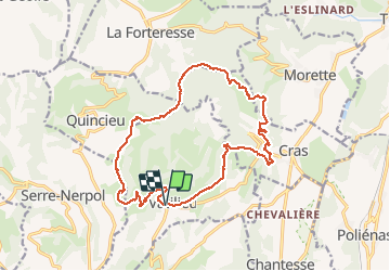
Vatilieu

philou68
User

Length
17.8 km

Max alt
780 m

Uphill gradient
780 m
Km-Effort
28 km

Min alt
372 m

Downhill gradient
782 m
Boucle
Yes
Creation date :
2020-02-05 08:03:25.714
Updated on :
2020-02-05 14:30:17.655
6h25
Difficulty : Very easy

FREE GPS app for hiking
 SityTrail
IGN / Geographical institutes
SityTrail Plus
The world is yours!
About
Trail Walking of 17.8 km to be discovered at Auvergne-Rhône-Alpes, Isère, Vatilieu. This trail is proposed by philou68.
Positioning
Country:
France
Region :
Auvergne-Rhône-Alpes
Department/Province :
Isère
Municipality :
Vatilieu
Location:
Unknown
Start:(Dec)
Start:(UTM)
688952 ; 5014225 (31T) N.
Comments