


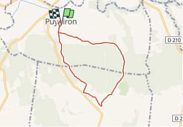
Puygiron 7km

thonyc
User GUIDE

Length
7.1 km

Max alt
243 m

Uphill gradient
122 m
Km-Effort
8.7 km

Min alt
162 m

Downhill gradient
128 m
Boucle
Yes
Creation date :
2020-02-05 12:57:41.202
Updated on :
2021-12-09 14:28:01.692
2h00
Difficulty : Easy

FREE GPS app for hiking
 SityTrail
IGN / Geographical institutes
SityTrail Plus
The world is yours!
About
Trail Walking of 7.1 km to be discovered at Auvergne-Rhône-Alpes, Drôme, Puygiron. This trail is proposed by thonyc.
Photos


Positioning
Country:
France
Region :
Auvergne-Rhône-Alpes
Department/Province :
Drôme
Municipality :
Puygiron
Location:
Unknown
Start:(Dec)
Start:(UTM)
646856 ; 4933751 (31T) N.
Comments