


Fonfréde

Gegetop
User
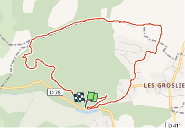

Length
6.1 km

Max alt
631 m

Uphill gradient
216 m
Km-Effort
9 km

Min alt
426 m

Downhill gradient
225 m
Boucle
Yes
Creation date :
2020-02-06 12:52:57.802
Updated on :
2020-02-06 14:26:25.568
1h30
Difficulty : Very easy

FREE GPS app for hiking
 SityTrail
IGN / Geographical institutes
SityTrail Plus
The world is yours!
About
Trail Nordic walking of 6.1 km to be discovered at Auvergne-Rhône-Alpes, Puy-de-Dôme, Châtel-Guyon. This trail is proposed by Gegetop.
Description
Boucle avec dénivelé de 230m.
Photos

Positioning
Country:
France
Region :
Auvergne-Rhône-Alpes
Department/Province :
Puy-de-Dôme
Municipality :
Châtel-Guyon
Location:
Unknown
Start:(Dec)
Start:(UTM)
504680 ; 5086386 (31T) N.
Comments