


les Avins

r.genette
User
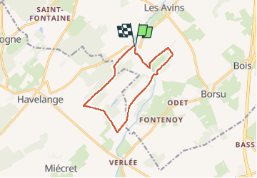

Length
10.4 km

Max alt
309 m

Uphill gradient
161 m
Km-Effort
12.5 km

Min alt
223 m

Downhill gradient
161 m
Boucle
Yes
Creation date :
2020-02-06 11:59:42.7
Updated on :
2022-09-21 08:54:29.352
2h30
Difficulty : Easy

FREE GPS app for hiking
 SityTrail
IGN / Geographical institutes
SityTrail Plus
The world is yours!
About
Trail Walking of 10.4 km to be discovered at Wallonia, Liège, Clavier. This trail is proposed by r.genette.
Description
Superbe rando.. très jolis paysages.
Positioning
Country:
Belgium
Region :
Wallonia
Department/Province :
Liège
Municipality :
Clavier
Location:
Unknown
Start:(Dec)
Start:(UTM)
662415 ; 5585947 (31U) N.
Comments