


autour de Gaschney

gdela
User
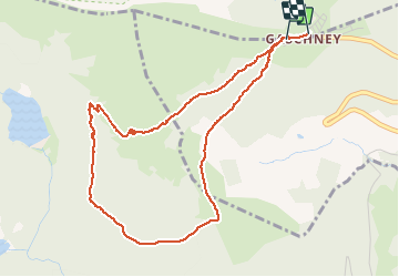

Length
4.6 km

Max alt
1138 m

Uphill gradient
185 m
Km-Effort
7.1 km

Min alt
972 m

Downhill gradient
194 m
Boucle
Yes
Creation date :
2020-02-07 08:49:41.246
Updated on :
2020-02-08 16:23:56.022
2h13
Difficulty : Medium

FREE GPS app for hiking
 SityTrail
IGN / Geographical institutes
SityTrail Plus
The world is yours!
About
Trail Walking of 4.6 km to be discovered at Grand Est, Haut-Rhin, Stosswihr. This trail is proposed by gdela.
Positioning
Country:
France
Region :
Grand Est
Department/Province :
Haut-Rhin
Municipality :
Stosswihr
Location:
Unknown
Start:(Dec)
Start:(UTM)
354281 ; 5321953 (32U) N.
Comments