


Des Bargettes à Langogne J2

BrassensJC
User
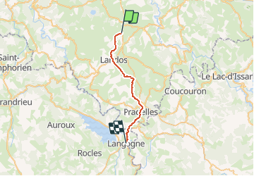

Length
23 km

Max alt
1237 m

Uphill gradient
308 m
Km-Effort
28 km

Min alt
899 m

Downhill gradient
482 m
Boucle
No
Creation date :
2020-02-07 11:34:41.246
Updated on :
2020-02-07 11:36:04.478
5h57
Difficulty : Very difficult

FREE GPS app for hiking
 SityTrail
IGN / Geographical institutes
SityTrail Plus
The world is yours!
About
Trail Walking of 23 km to be discovered at Auvergne-Rhône-Alpes, Haute-Loire, Landos. This trail is proposed by BrassensJC.
Positioning
Country:
France
Region :
Auvergne-Rhône-Alpes
Department/Province :
Haute-Loire
Municipality :
Landos
Location:
Unknown
Start:(Dec)
Start:(UTM)
566835 ; 4970045 (31T) N.
Comments