


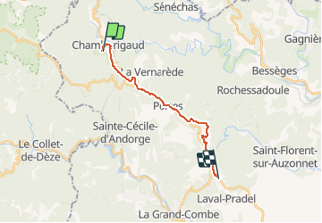
de Chamborigaud au Pradel GR700

BrassensJC
User

Length
16.1 km

Max alt
572 m

Uphill gradient
394 m
Km-Effort
21 km

Min alt
298 m

Downhill gradient
411 m
Boucle
No
Creation date :
2020-02-07 16:03:06.804
Updated on :
2020-02-07 16:04:06.075
4h33
Difficulty : Very difficult

FREE GPS app for hiking
 SityTrail
IGN / Geographical institutes
SityTrail Plus
The world is yours!
About
Trail Walking of 16.1 km to be discovered at Occitania, Gard, Chamborigaud. This trail is proposed by BrassensJC.
Positioning
Country:
France
Region :
Occitania
Department/Province :
Gard
Municipality :
Chamborigaud
Location:
Unknown
Start:(Dec)
Start:(UTM)
577473 ; 4905682 (31T) N.
Comments