


Espinasse - Tallard

DaVinci
User
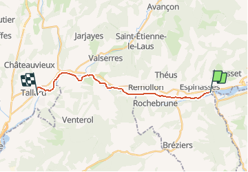

Length
16.8 km

Max alt
656 m

Uphill gradient
85 m
Km-Effort
18.1 km

Min alt
590 m

Downhill gradient
143 m
Boucle
No
Creation date :
2020-02-08 10:39:44.111
Updated on :
2020-02-08 10:48:25.141
2h50
Difficulty : Medium

FREE GPS app for hiking
 SityTrail
IGN / Geographical institutes
SityTrail Plus
The world is yours!
About
Trail Canoe - kayak of 16.8 km to be discovered at Provence-Alpes-Côte d'Azur, Hautes-Alpes, Rousset. This trail is proposed by DaVinci.
Positioning
Country:
France
Region :
Provence-Alpes-Côte d'Azur
Department/Province :
Hautes-Alpes
Municipality :
Rousset
Location:
Unknown
Start:(Dec)
Start:(UTM)
279858 ; 4927098 (32T) N.
Comments