


sion

sterdyniak
User

Length
21 km

Max alt
530 m

Uphill gradient
715 m
Km-Effort
30 km

Min alt
325 m

Downhill gradient
718 m
Boucle
Yes
Creation date :
2020-01-26 09:26:25.154
Updated on :
2020-02-10 07:36:59.25
4h02
Difficulty : Medium

FREE GPS app for hiking
 SityTrail
IGN / Geographical institutes
SityTrail Plus
The world is yours!
About
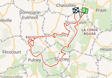
Trail Running of 21 km to be discovered at Grand Est, Meurthe-et-Moselle, Saxon-Sion. This trail is proposed by sterdyniak.
Positioning
Country:
France
Region :
Grand Est
Department/Province :
Meurthe-et-Moselle
Municipality :
Saxon-Sion
Location:
Unknown
Start:(Dec)
Start:(UTM)
284335 ; 5368146 (32U) N.
Comments