


refuge de la Croix Lus la croix haute

Atchoum26
User
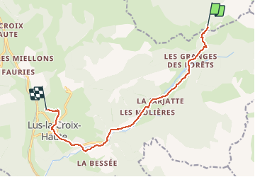

Length
11.7 km

Max alt
1492 m

Uphill gradient
66 m
Km-Effort
14.1 km

Min alt
1011 m

Downhill gradient
533 m
Boucle
No
Creation date :
2020-02-10 07:43:02.544
Updated on :
2020-02-10 11:24:19.503
3h30
Difficulty : Medium

FREE GPS app for hiking
 SityTrail
IGN / Geographical institutes
SityTrail Plus
The world is yours!
About
Trail Walking of 11.7 km to be discovered at Auvergne-Rhône-Alpes, Isère, Tréminis. This trail is proposed by Atchoum26.
Positioning
Country:
France
Region :
Auvergne-Rhône-Alpes
Department/Province :
Isère
Municipality :
Tréminis
Location:
Unknown
Start:(Dec)
Start:(UTM)
720308 ; 4953613 (31T) N.
Comments