


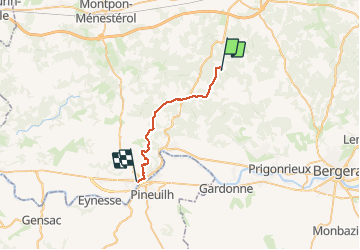
P04 La Gratade-Port Ste. Foy

HEKABI
On ne s'arrête pas parce qu'on vieillit, ... on vieillit parce qu'on s'arrête !

Length
22 km

Max alt
155 m

Uphill gradient
306 m
Km-Effort
26 km

Min alt
10 m

Downhill gradient
412 m
Boucle
No
Creation date :
2020-02-10 13:03:08.704
Updated on :
2020-02-10 13:08:10.25
5h28
Difficulty : Very difficult

FREE GPS app for hiking
 SityTrail
IGN / Geographical institutes
SityTrail Plus
The world is yours!
About
Trail Walking of 22 km to be discovered at New Aquitaine, Dordogne, Fraisse. This trail is proposed by HEKABI.

Positioning
Country:
France
Region :
New Aquitaine
Department/Province :
Dordogne
Municipality :
Fraisse
Location:
Unknown
Start:(Dec)
Start:(UTM)
288897 ; 4981039 (31T) N.
Comments