


Marigny rando Jean Claude page 158

grasgilbert
User
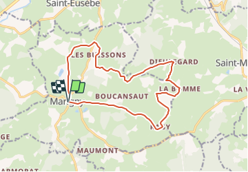

Length
15.8 km

Max alt
415 m

Uphill gradient
293 m
Km-Effort
19.7 km

Min alt
295 m

Downhill gradient
291 m
Boucle
Yes
Creation date :
2020-02-10 13:06:38.182
Updated on :
2021-08-05 16:02:09.455
--
Difficulty : Medium

FREE GPS app for hiking
 SityTrail
IGN / Geographical institutes
SityTrail Plus
The world is yours!
About
Trail On foot of 15.8 km to be discovered at Bourgogne-Franche-Comté, Saône-et-Loire, Marigny. This trail is proposed by grasgilbert.
Description
Rando Jean Claude
Positioning
Country:
France
Region :
Bourgogne-Franche-Comté
Department/Province :
Saône-et-Loire
Municipality :
Marigny
Location:
Unknown
Start:(Dec)
Start:(UTM)
611628 ; 5170550 (31T) N.
Comments