


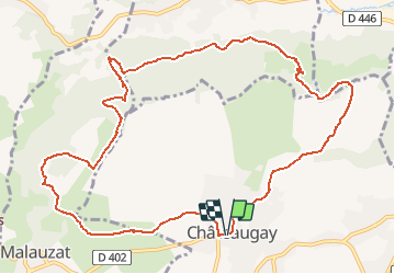
Chateaugay champs griaud marcoin

jeanic63
User

Length
12.8 km

Max alt
557 m

Uphill gradient
285 m
Km-Effort
16.6 km

Min alt
380 m

Downhill gradient
286 m
Boucle
Yes
Creation date :
2020-02-11 16:19:02.506
Updated on :
2020-02-13 09:57:36.678
--
Difficulty : Medium

FREE GPS app for hiking
 SityTrail
IGN / Geographical institutes
SityTrail Plus
The world is yours!
About
Trail On foot of 12.8 km to be discovered at Auvergne-Rhône-Alpes, Puy-de-Dôme, Châteaugay. This trail is proposed by jeanic63.
Description
Départ Chateaugay parking Charles de Gaulle
Positioning
Country:
France
Region :
Auvergne-Rhône-Alpes
Department/Province :
Puy-de-Dôme
Municipality :
Châteaugay
Location:
Unknown
Start:(Dec)
Start:(UTM)
506566 ; 5077375 (31T) N.
Comments